Salon Editor Explains Why Some U.S. House Districts Look the Way They Do [MAP]
Author argues Republicans lumped Democrats together to create more conservative districts.

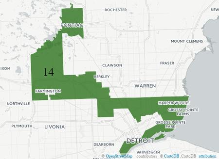
When President Barack Obama took office in 2009, the Democratic Party controlled both houses of Congress. Two years later, Republicans had won back the U.S. House and regained control of the Senate in 2015. How did they do it? The author of a new book argues that GOP operatives devised a plan to redraw congressional boundaries to ensure Republicans would hold majorities even if Democrats won more aggregate votes. Salon Editor-in-Chief David Daley presents his case in “Ratf**ked: The True Story Behind the Secret Plan to Steal America’s Democracy”. The key part of the plan, he writes, was 2010 Census data, which state legislatures used to redraw congressional district boundaries based on population shifts. Daley tells WDET’s Pat Batcheller Michigan’s Republican-led Legislature “gerrymandered” the 14th Congressional District to connect two of the poorest cities in the state–Detroit and Pontiac.
“The goal behind this is to pack as many African-American and Democratic voters into that snake in the 14th district as they can in order to take the districts around them and make them more conservative, whiter, and more Republican,” Daley says.

Daley points out that gerrymandering has been around since the country’s early days, and both parties have done it to give themselves more political power. He adds that the current Congressional map is so solidly “red” that if Republican presidential nominee Donald Trump loses in November, it won’t hurt GOP candidates down the ballot.
“The idea that those same Republicans in these incredibly tilted districts will also say that they want to have a Democrat in Congress along with a Democratic president seems to me to be unlikely,” Daley says.
Click on the audio player above to hear the conversation.

